Markus Bergelt
- Username
- Markus Bergelt
- Joined
- Visits
- 845
- Last Active
- Roles
- Member, Author
Activity
-
 Hi, MarkusDoes GeoLayers 3 has an API?I want to use it in scriptingFebruary 19
 -
 Hi Markus,I'm having trouble controlling the map view within the GeoLayers extention tab.I can use the cursor to adjust the pitch and bearing (right click). This works.But when I left-click to change position along long and latitude, nothing happens.I think this might be a glitch?What is going on?At the moment I have to use the longitude and latitude values in the effects tab to set key-frames. This is incredibly frustrating.Please advise.AdamNovember 2023
 -
 hey markus...i m experiencing trouble while using geo layers3 ....sometimes "a thin white line appears on mapcomp" and it does not go even after finalizing many times ....please HELP ...July 2023
 -
 Hi there, is there a way to link google maps so they are used as the tile images?September 2022
 -
 Hello Markus,Love GeoLayers a great program! Thank you!Question, the shape layers of countries comes from what source? Open Street Maps?In particular Russia's layer has Crimea in it, when it doesn't exist in the Ukraine shape file.Unfortunately, with the different transforms, I cannot copy the shape from one layer to another. Do you know of a workaround? Maybe I'm missing something obvious.Thank you,CyrilJuly 2022
 -
 Hey Markus!Is there any way to get another Geo Layers 3 free trial or to extend the existing one?I sadly had massive hardware Problems with my Mac a day after activating the trial..Thanks und liebe GrüßeDominik KunzMay 2022
 -
 Hi mate,Is GeoLayers compatible with the new M1 chip on the Mac? I would like to buy it now whilst it's on sale but need to make sure it is going to work!ThanksSamJune 2021
 -
 April 2021
 -
I've been combining GeoLayers with element 3d. You can parent the null objects from element 3d to your mapcomp anchor.April 2021
-
 Hi Markus,
i have a question concerning geolayers 3
are features not saved with the AE project?
do i need to create a json file to conserve them for everytime it open or edit a project ?
i have seen i can extract features from labels but this is only partly usefull....
looking forward to your feedback
cheers FlorianNovember 2020 -

-
-
 Hi Markus, I was wondering if there is a way to "boost elevation" when using Plexus? I saw in the Everest Walk through tutorial there is a custom slider for boosting the elevation shown here:
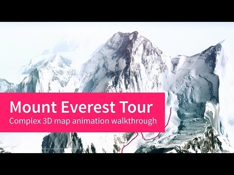 Do you have any info on how I could create that same custom slider for use with Plexus? Thanks, MichaelFebruary 2018
 -
 I'd like to buy this, but are these maps clearable to use for television worldwide. Are they all royalty free, do the maps have to have relevant copyright logos on? Are there credits required in end titles etc. I'd like to buy this but I can also envisage production managers asking me what the legalities are of these images?ThanksMarkFebruary 2018
 -
 Hi there!Im Cep extension expert developer. we can have some Cooperation to build more cool tools for aftereffects. im working on aftereffects extensions about 2 years. however i worked for some other famous publishers in videohive before.Best Regards,Daniel smithJanuary 2018
 -
 I posted the note below via aescripts support for GEOlayers 2. I'm not sure how to get "support" and hope you might help out here.I have recently installed GEOlayers 2 and Trapcode Mir 2. When I open AE, it get a working dashboard and then a "start" panel pops up that is blank and can be closed via "X" in right corner. When I open the Geolayers 2 extension, I get a empty floating controls panel, ergo - not GEOlayers 2 features! The dropdown menu allows me to pick options like "preferences" etc. but all those popup panels are also empty - ?January 2018
 -
-
 Hi Markus, I am interested in buying Geolayers. can you explain more about the attributions part? I make a lot of maps for TV but copyright is always an issue so I tend to use Nasa maps.
basically on a tv show, the attributions would have to be in the end credits not on the map itself....is this a problem? Can you tell me the workflow for not having the attribution on the map for a tv show?.
thanks
NeilAugust 2017 -

-
 Hi, Markus.We have a problem to create new server profile for ArcGis tiled-map service in GEOLayers-2 plug.Actually we are owners of ArcGis Server and we try to help to person that uses AfterEffect softwarewith GEOLayers-2 plug to connect to our map service.We tryed to use following instructions from this Blog:============================================go to the Preferences and add a new server profile. For example: arcgis_samplechoose the Universal Apicheck "enable tile download"paste this URI Mask:finally choose file extension "png"apply the prefs and assign the profile to a Mapcomp.=============================================Doing all this produced blank map window with no result.In this blog was announcement that ArcGis Server is supported as Tiled Map provider.The link to our sample map is correct:And this map for the sake of simplicity is "public", no need to login.May be we are doing something wrong and you can help us with more precise instructions ?Thank you in advance,YakovApril 2017
 -
 Hi Markus, first let me thank you for this great piece of software! Now to my problem: I get some bluish tiles after finalization. Is there a way to get rid of those?RegardsGeorg
 February 2017
 -
 Markus,We have multiple uses of GeoLayers in one video. Can we give all credit at the end of the piece rather than overlayed on each individual graphic? Please let me know if this is acceptable or what we need to do in order to credit in this manor.Our time is getting very limited so I'd really appreciate a response.Thanks,DerekFebruary 2016
-
 Delano SamuelsHey Derek, have you had any success with getting in touch with Markus or anyone on the DEV team to resolve any issues? Support seems a bit scary, since you have been trying to get in touch for so long and no progress.
-
-
Hi Markus,I have been trying to reach you about giving proper credits for the use of GeoLayers in a project. Could you please email me ASAP so that we can discuss this matter? We would like to pay you additional fees depending on how we are allowed to credit.Please email me at [email protected] as soon as you get a free minute.Thanks so much,Derek Bronsteenwww.superstructla.comFebruary 2016
-
Hi Markus,Is there any way we could speak via telephone to expedite a few questions I have about giving proper credit?I am a motion graphics artist and have created multiple maps with your fantastic tool GeoLayers! The client is strongly against having the copyright bugs on every map and would love to credit you guys for all of the work at the end of the documentary. Is this possible?Please feel free to email me directly at [email protected]Thanks so much!DerekJanuary 2016
-
Hey Markus,We are working on a documentary project and have created a few maps with GeoLayers. First of all thank you for creating such a wonderful tool! We are wondering if there is a way we can give credit to all the map sources at the end of the film rather than put a stamp on each individual map. Would this be OK?Cheers,DerekJanuary 2016
-
Also having an issue with licenses. We have been using GeoLayers intensively on our current product. We had to buy a 2nd license to run renders on 2 machines. However now it is saying that both machines are reading the same license. I have deleted "uninstalled" the file from Adobe AE > ScriptUI, restarted, reinstalled again and again, I cannot get it to prompt me for a license it just gives me the red X.All that said I'd really appreciate your help and we are loving this plugin for the most part. We do a lot of high profile jobs, www.superstructla.com , so we will be happy to share our results afterwards.Thanks,DerekOctober 2015
-
 same problem as Guillaume Lenfant'GEOlayers_comp_1' is not existing in your projecterror downloading Imagery Metadata..something wrong with the internet connection, but how can i solve it?October 2015
 -
 I would like to move over the pacific ocean. But the map has a border at New Zealand.How can I go on?April 2015
