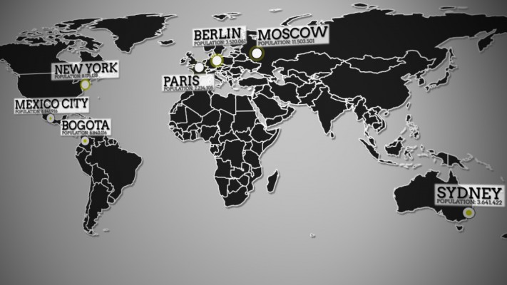
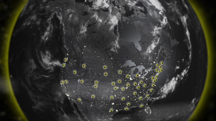
Locations
-
Compatibility After Effects Please check exact version compatibility under the "COMPATIBILITY" tab below
 Adding to cart...
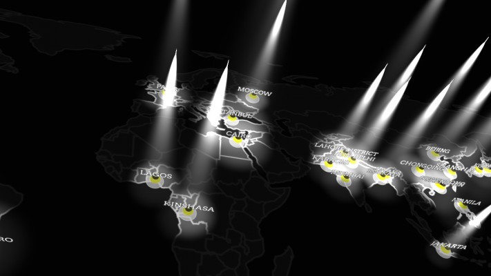
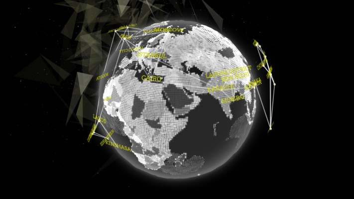
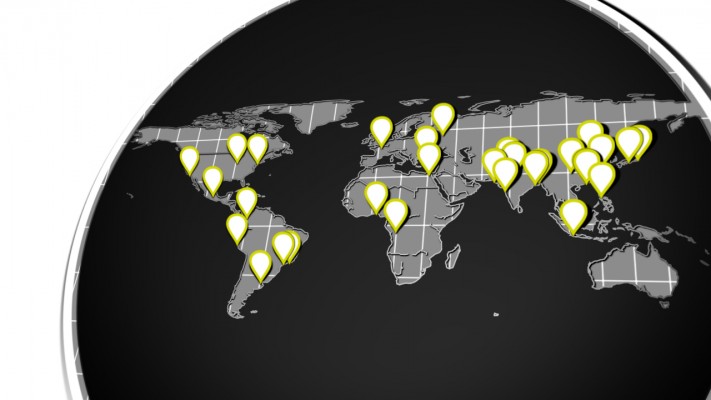
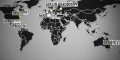
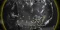
 Create 2D and 3D geo located markers on an equirectangular map or projected onto a sphere. In other words, add map location data to your After Effects comp quickly and easily!
Interface Overiview
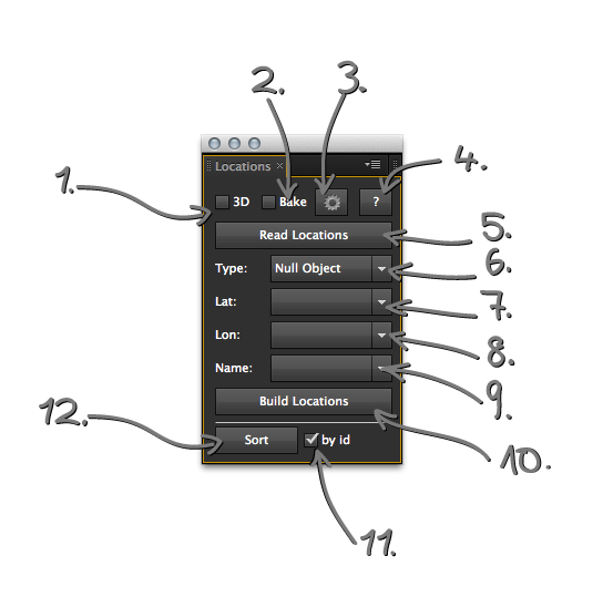
1. 3D Checkbox:
If you enable the 3D option the markers you create will be created using cartesian coordiantes. That allows you to place them on a sphere. These markers are bound to an center layer that has aslider for the radius of that sphere. If this is unchecked your comp needs to be in an 2:1 ratio.
2. bake Checkbox:
If you enable this the script will use the AE positions. The expression that calculates the position based on lat lon is still there but disabled.
3. Cogwheel Button:
Opens the settings panel. There you can set if you use comma or tab separated values. Add a prefix and suffix for the text and change the layer name prefix.
4. ? Button:
Opens the help. Duh.
5. Read Locations Button:
This button opens a file chooser dialogue. Select an .tsv or .csv file. The Script only can handle tab or comma separated values. It will parse the content of the file and try to fill your latitude, longitude and text dropdown.
6. Marker Type Dropdown:
0 --> nothing
1 --> nullObject
2 --> LightLayer
3 --> TextLayer
4 --> SolidLayer
5 --> Marker Precomp
There are different type of markers. LightLayers will be handled different than the rest due to the fact that lights can't have effects. So the script will calculate the real position and not, like the rest, add 2 angle controllers that can be used to change the lat long degrees. If you choose the Marker Precomp option the script will create a tiny comp that will be used as marker.
7. Lat Dropdown:
Select the latitude row of your csv after reading it in. If your row is named lat/latitude/Latitude/LAT/Lat the script will find them end set them for you.
8. Lon Dropdown:
Select the longitude row of your csv after reading it in. If your row is named lon/longitude/Longitude/LON/Lon the script will find them end set them for you.
9. Name Dropdown:
Select the row that should be used as text. This text will always be the layername and if you use textlayers it also will be its content. If your row is named name/Name/NAME/city Name/etc the script will find them end set them for you.
10. Build Locations Button:
This will create your markers.
11. NEW By id Ceckbox:
This allows you to sort the layers by the given id in the layers name.
12. NEW Sort Button:
Hit the button and the script will try to sort by the give field in the name dropdown (9) or by the id the script creates in the layers name.
Get and Create Geo Data
You can find lots of geo data in the web. For example here:
- getlatlon.com
- geocommons.com
- geonames.org
But there is more going on. For example has twitter an API that gives you geolocations. With this url:
http://search.twitter.com/search.json?geocode=37.781157,-122.398720,1mi
You get all the recent tweets that are geo referenced within an one mile radius around that location.
Or maybe NA weather stations? You just need to find some way to turn these datasets into .csv or .tsv. Geocommons can be helpfull with that. Have a quick look into this tutorial on creating geodata with geocommons.


| After Effects | CC 2015, CC 2014, CC, CS6, CS5.5, CS5, CS4 |
|---|
0.4.3 (Current version) - Jun 21, 2015
0.4.1 - Jun 5, 2014
0.4 - March 2014
- projections are working woohoo! \o/
0.3.2 - February 2014
- started projections
- added extendscript.geo lib
- added grunt development
0.3.1 - October 2013
- some big fxing
0.3 - July 2013
- added automagically sort feature and safer coding
0.2.3 - May 2013
- Edit 2D location expression to change z-Position
0.2.2 - February 2013
- radius slider with keyframes bug fix
0.2.1 - February 2013
- radius slider bug fix
0.2 - December 2012
- Safer Coding
uniquer names, more encapsulation, loop bug fix
0.1.2 - December 2012
- fixed issue value is NAN. Some code cleaning
0.1.1 - December 2012
- code cleaning and debugging
0.1 - December 2012
- initial release
-

- Compatibility After Effects
AEMap
A dockable scripts panel that builds maps for you directly in AE.Add to Cart
Use the build in boundaries and jurisdictions or import your own. Colorize the shapes or masks based on data. Precompose by jurisdiction. Use different projection types like mercator, equirectangular, aitoff and more. It comes with the "AEMap Utilities" which contains tools for dealing with a bunch of layers and nested comps. -

- Compatibility After Effects
Zorro-The Layer Tagger
Zorro lets you group layers in after effects by adding tags to layers. Similar to the way you would tag photos in Flickr, you can tag layers in your comps and then select or isolate those layers in groups by using the tags.Add to Cart -

- Compatibility After Effects
Faux Parent
Add to CartFaux Parent will give you all the power of normal parenting, but with the freedom that you will never get from a "real" parent. Faux Parent allows you to decide how much control the parent can have over the child in Adobe After Effects.
-

- Compatibility After Effects
Slice it Up 2
Procedural and non-destructive way to slice your footage in After Effects. Buy it with the AI or C4D version for a 10% discount or all 3 for a 20% discount.Add to Cart -

- Compatibility After Effects
LayerGenerators
Add to CartA collection of 3 tools for After Effects to automate the creation of layers.
LayerGenerator is discounted 50% for students and faculty.
More info here. -

- Compatibility After Effects
Advanced Selection
Add to CartExpands the capabilities of After Effects to select layers. It offers a vast amount of filters you can choose from to narrow down your selection, like layer types, layer options, blending modes, search by name, label colors, and more.
-

- Compatibility After Effects
Monoline Text
Monoline Text creates text from a single stroke vector set as mask on solids, shape layers or motionpaths. You can have all on one single layer, separate it by line or have every character as an individual layer.Add to Cart$34.99 -
- Compatibility After Effects
AEMap
A dockable scripts panel that builds maps for you directly in AE.Add to Cart
Use the build in boundaries and jurisdictions or import your own. Colorize the shapes or masks based on data. Precompose by jurisdiction. Use different projection types like mercator, equirectangular, aitoff and more. It comes with the "AEMap Utilities" which contains tools for dealing with a bunch of layers and nested comps.$42.23 -

- Compatibility After Effects
Timeremap Source
Keep your compositions clean by stacking and precomposing multiple layers. Make them accessible via an expression slider.Add to Cart$9.99 -

- Compatibility After Effects
OBJ Vertex Export
Export wavefront OBJ vertex point clouds from After Effects layer positions.Add to Cart$14.99 -

- Compatibility After Effects
Swissd
Swissd is an After Effects script for creating fixed width text layouts. You can just have fun with the buzz generator and skip thru your fonts or do some serious work with it. It uses the scale property of the text layers to resizes them to fit in the same width.Add to Cart$29.99